
Paraguay. A Buffer State.
A landlocked country with almost all its rivers navigable. The difficult road to independence. Lugo’s parenthesis. The world of the triple frontier. The landed oligarchies.
Paraguay nestles in the heart of the southern Latin American cone between Bolivia, which surrounds it to the north and northwest, Brazil which it borders to the east, and Argentina to the south, southeast and southwest.The country, whose territory is predominantly hilly with reliefs that do not exceed a thousand meters in height, has no access to the sea. This closure is compensated for by being a river platform, the centre of the passage of the major rivers, all navigable, which cross Latin America from north to south, from which it is possible to reach various other areas. Among the major rivers, Paraguay certainly stands out, from which the country takes its name and whose length is 2,620 km. It originates in the Brazilian region of Mato Grasso, flows briefly through Bolivia, enters the interior of the country crossing it from north to south forms the southern border with Argentina, and then flows to the right of the Paraná River in the Triple Frontier area.
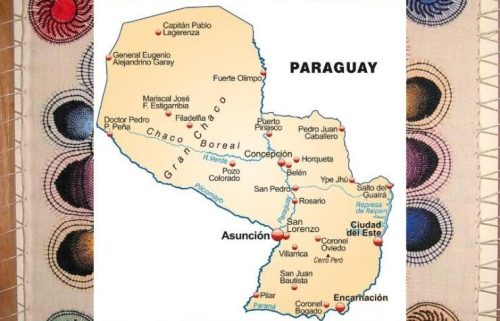
Paraguay map. 123rf
The Paraguay River, flowing within the country for 1,300 km, divides the nation into two distinct parts both at a geo-morphological and population level considering that to the west of it, in the Chaco, less than 3% of Paraguayans live in an area that corresponds to 61% of the country. This area, arid and impervious, has always been perceived as a marginal space unsuitable for human settlement, unlike the southeastern region, rich in natural resources, which constitutes the socio-economic engine of the country.
Proof of this is the fact that, while the former hosts only three departments in which two hundred thousand of the over seven million inhabitants live, the latter has only fourteen departments. As the analyst Federico Larsen highlights, the existence of a small thriving production centre and an immense under-exploited and under-protected periphery reflects a constant in history that many South American countries have in common.In addition to the Paraguay River, there is the Paraná, whose length is 4,800 km, 800 of which flow through Paraguayan territory, delineating part of the border with Brazil and the border with Argentina, while in the western part there flows the Plicomayo which originates in the Andes, flows for approximately 1,800 km, including the Bolivian and Argentine sections, and then joins the Paraguay river of which it is the largest right-hand tributary.Unlike the number of its rivers, the territory is not very rich in lake basins.
Among the most important we have Lake Ypacaraí whose diameter is 56 km² and is located near Asunción, the capital. The country can also boast of possessing the Guarani aquifer which constitutes one of the largest underground freshwater reservoirs on the planet.
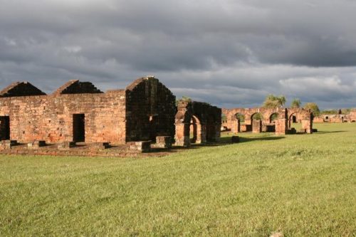
Ruins of the Jesuit Guarani reduction La Santisima Trinidad de Parana, UNESCO World Heritage Site, Paraguay. File swm
Before the arrival of the Spanish conquistadores, around the year 1500, the area was sparsely populated and its only residents were the farmers of the Guarani, a population who immediately showed hospitality towards the expeditions, passing through their territories and in transit towards the Rio de la Plata in search of gold and silver mines.
The geographical position, the navigability of the rivers and the hospitality of the inhabitants constituted optimal conditions for conceiving the territory as a strategic base both for the control of the entire southern cone and for the achievement of the mining objectives in the Rio de la Plata, the latter being downsized following the discovery of the very rich Peruvian and Bolivian mines.
In this era, the Reductions experiment was carried out by the Jesuit Fathers aimed at promoting coexistence between Europeans and natives, i.e., self-sufficient communities capable of producing what they needed to live and defend themselves. This project constituted an important piece of a broader political plan of the Spanish Crown aimed at putting a stop to the exploitation of the natives and limiting Portuguese ambitions in South America.
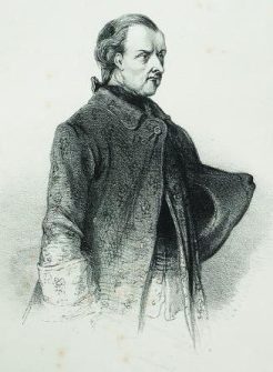
José Gaspar Rodríguez de Francia. Doctor Francia’s long regime lasted until 1840. Museo Histórico Nacional de Uruguay
Until 1782, the area represented an important epicentre of local equilibrium. It is no coincidence that the Spanish kingdom decided that the largest province of the Viceregency of Peru would be that of Paraguay which initially extended to Tierra del Fuego, allowing access to both the Pacific and the Atlantic. Subsequently, the area lost its importance, both because it was deprived of an outlet to the sea and due to the growth of other regional realities and above all, that of Buenos Aires, continuing however to represent a bastion of defence for the Spaniards against the indigenous insurrections of the Chaco and against the ‘Portuguese Empire’ in the East.
In 1811, the country acquired independence at the cost of commercial isolation from Buenos Aires whose intent was to establish a sort of protectorate over Asunción. Argentine determination was such that it attempted to obtain the objective even through an invasion, repelled by a massive reaction which saw the mobilization of all sectors of society. The event constituted a watershed in the history of the country and favoured the immediate creation of an army and a government, led by the landed aristocracy, whose father was the liberal Jacobin José Gaspar García y Rodríguez de Francia, better known as Doctor Francia.
Doctor Francia’s long regime, which lasted until 1840, was characterized by a policy aimed at making Paraguay an autonomous industrial power. In those years, the country was one of the first to equip itself with its railway and carry out other important public infrastructure works, but also to impose customs duties aimed at protecting products. At a regional level, it developed an interchange with Montevideo, seeking to maintain free trade on the rivers that connected it to the Atlantic.
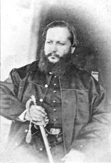
Francisco Solano Lopez Carrillo. Photo: Domenico Parodi
Doctor Francia’s policy was carried out by the Lòpez family under whose guidance the foundries, shipyards, metalworking industries, and water infrastructure were built which gave a strong impetus to agricultural activities. This policy, supported by the popular classes, the medium-sized producers and the lower clergy worried both the powers of the region, Argentina and Brazil, and Great Britain. The latter, in particular, worked to limit the industrial development of the entire region to guarantee a market for its manufacturing and secure the raw materials necessary for its production. Thus, the development that the country had known up to that point was interrupted following the defeat suffered in the disastrous war against the Triple Alliance – Brazil, Argentina, and Uruguay – still considered today the greatest national tragedy, in which Paraguay suffered a drastic territorial reduction, the extermination of the adult population and the elimination of the industrial sector which was razed to the ground. (Open Photo: Paraguayan flag.123rf)
F.R.
